

Filters
Data type
Hyperspectral data
LiDAR data
Orthophoto
Thermal data
Thematic outputs
Ecosystem type
Forest
Urban
Agro-ecosystem
Water
Acquisition date
August 28, 2019
Datasets
HS VNIR
HS SWIR
HS LWIR
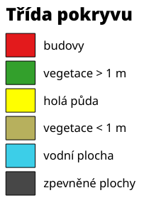
Classification of surface classes
Height of city object
Surface Emisivity
LD 11:05 4 p/m²
Dataset information
Title: Classification of surface classes
Date: August 28, 2019 at 11:05 AM UTC
Data type: Thematic outputs
Ecosystem type: Urban
Description: Created with support from project TACR TL02000322 Thermal comfort in urban areas: human perception, physics based reality, role of greenery.